Week 1: Objective- Learn how geographers use maps and other visual representations to understand geographic data.
Tuesday- Determine what you know and what you need to learn in geography.
Activities: letter home, discussion about class goals, get to know you activity
Wednesday-Students will gather data to draw conclusions from maps and other visual representations (2-1b), and will present geographic information in chart form (2-1c).
Activities 1- geography pre-test
Activity 2- Homework: Due next Wednesday. Using the attached Graphic Organizer, define these geography terms. Or draw a picture to define the term.
8/18 & 8/22- Students will gather data, make inferences, and draw conclusions from maps and other visual representations (2-1a); will locate human features and evaluate their implications for people and societies (2-1d).
bellringer: Create a themes of geography chart for the part of Plateau Valley where YOU live (Mesa, Molina, Collbran, or DeBeque)
GO OVER UNIT OBJECTIVES
Activity 1- notes on 5 themes of geography
Activity 2-Formative assessment- Plateau Valley and the 5 themes of geography
8/23- CURRENT EVENTS DAY
8/24: Students will be able to explain the importance of location in geography.
Bellringer: WHY DOES LOCATION MATTER?
Activity 1-Answer the following questions and discuss the answers in small groups, then as a whole group: what is your relative location? what is the relative location of Plateau Valley? Colorado? the US? When would you use relative location to describe a place? When would it NOT make sense to use relative location to describe the location of an area?
Activity 2-absolute location activity- using the maps from page RA16-RA40, find the ABSOLUTE location of the following cities: Denver, Washington DC, Buenos Aires, Sydney, Moscow, Greenwich (England). Answer the following questions: 1) What does absolute location tell us? 2) When would it be important to know the absolute location of a place? 3) Why do geographers divide the Earth into four hemispheres? 4) WHY DOES LOCATION MATTER? How does location affect humans?
Activity 3-Choose any country from around the world to do a 5 themes project.
Vocabulary graphic organizer due today! Go over vocab as a class.
Students will gather data, make inferences and draw conclusions from maps and other visual representations,
create and interpret various graphs, tables, charts, and thematic maps, analyze and present information using a variety of geographic tools and geographic findings in graphs, tables, charts, and thematic maps, and locate physical and human features and evaluate their implications for society.
8/24- Objective-Demonstrate ability to use geographic tools and research to present information.
bellringer: Select a country anywhere in the world that you find interesting.
Activities: 5 themes projects
8/29-Objective-Demonstrate ability to use geographic tools and research to present information.
Activities:
work on 5 themes project
Vocabulary notes on map projections pp. 4-7
8/30- 5 theme country presentations
8/31-Objective-Demonstrate ability to use geographic tools and research to present information.
bellringer: discussion blog
Activity-present 5 themes project
9/12- Understand how geographer's use thematic maps and graphs to interpret and present geographic information (2-1b).
bellringer: what are the absolute and relative location of Bangor, Maine?
Activity 1-Notes on map projections p. 4-7. Discuss different types of map projections and how they might be used.
Activity 2- Watch presentation on "How Cartographers look at the world" and complete the corresponding note worksheet (assessment).
9/14-Understand how geographer's use thematic maps and graphs to interpret and present geographic information (2-1b).
bellringer: Numbers Tell a Story
activity 1- go over "Numbers Tell a Story" questions. Why would a geographer use a graph like this? Who else might use a graph like this and for what? "Reshaping the Nation" questions.
activity 2- Comparison of US population distribution over 100 years.
9/15-Demonstrate an understanding of how geographer's use thematic maps and graphs to interpret and present geographic information (2-1b); students will apply geography skills to propose a possible resolution to the uneven distribution of economic activity across the US (2-2a).
Activity 1-go over "Reshaping the Nation" cartogram and questions. Why would a geographer create such a map? How else might a geographer present this same information?
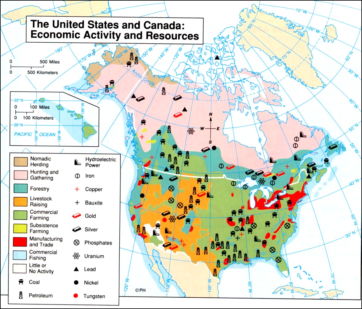
Activity 2- compare this map of the economic activities in the US and Canada to the cartogram in "Reshaping the Nation." Evaluate the information presented in each geographic tool and answer the following questions: 1) Is there a relationship between income and economic activity? 2) Evaluate how economic activity and income might be related. 3) Considering the relationship between income and economic activity, how might governors of low-income states increase the economic prospects of their states?
9/19-9/20:Objective-Learn the many types of jobs that exist in geography, and how the tools of geography are used in different fields.
Activities:
Watch introductory video on Geographic Information Systems. Explain how the GIS system and public health relate?
Look at GIS explanation sheet.
Activities: Watch the GPS/GIS video. Explain-what kind of people use GIS in their fields?
Investigate the various uses of maps through this website. Complete this questionnaire as you investigate.
9/21 Objective: Gather data and interpret graphs, tables, charts, and thematic maps
Bellringer: What type(s) of map(s) do you think search and rescue units use?
Activities:
Latitude & Longitude Worksheet with atlas
Complete endangered languages questions using graphs and charts in this presentation.
Complete the Arctic Data Rotation activity to practice using graphs, tables, charts, and thematic maps.*
9/8-9/10:
Objective: Gather data and interpret graphs, tables, charts, and thematic maps
Bellringer: Draw a chart that represents the ratio of residents of the following communities within your class-DeBeque, Collbran, Mesa, Molina. How might residency data be useful to the school district?
Activities: Complete "Numbers Tell a Story" handout.
Group Activity:
Divide class into two groups:
Group 1- Using the maps provided from the US census, complete the census survey to become familiar with the population demographics of the US.
Group 2- Complete the Electronic Census Map handout.
9-14: Students will use thematic maps to analyze information
Activity:
Vocabulary on Physical Earth-Review
Notes on Physical Earth (Chapter 2 in book)-Due Wednesday morning
9-15: Students will learn about the physical systems of the Earth.
Test on Map Skills. Share the document with me when you are done.
Activity:
Finish notes on Physical Earth when test completed.
9-16: Current Events today
9-21: Students will demonstrate understanding of the Earth's Physical systems.
Bellringer: What is the shape difference between a glacier valley and a valley created by running water?
Questions on the Physical Earth
10/12/16 & 10/13/2016: Students will learn about the Earth's Water Systems
Activity:
1) Draw a color diagram of the water cycle.
2) Complete the worksheet on the Earth's water systems.
9-23: Current Events
10/17/16: Students will demonstrate mastery of both physical systems of Earth and our water system.
Bellringer: What do you think is the greatest threat to the Earth's water system?
Activity: p. 46-47 review
10/18/16:
Exam C. 2
10/19/16 & 10/20/16: We will learn to identify types of climates found on Earth.
Exam discussion/correction
Activity 1- Complete oceans and seas of the world map
Activity 2- Notes on factors affecting climate. Use the internet and pp. 50-59 to complete the powerpoint notes.
Climate Zones Questionnaire (goes with last slide). If the link on slide does not work, here it is again. Ocean Services climate zones
10/24/16: We will use maps and online resources to identify the major vegetation regions of the world.
Bellringer: Label and describe the climate zone of Plateau Valley.
Activity:
Use National Geographic Education to take notes on the 5 major vegetation regions of the world, then match up those vegetation regions with their corresponding climate regions (in your notes).
10/25/16: Current Events
10/26/16: We will use maps and textbook resources to locate and describe the world's climate and vegetation zones.
Bellringer: NA-grade homework
Activity:
1) Color and label a vegetation zone map and a climate zone map using the maps on p. 62-63 in the textbook. Be sure to include a key for your maps.
2) Answer the following questions on a separate sheet of paper:
*What is the relationship between climate and vegetation?
*How do climate and vegetation zones affect patterns of human settlement? (You must utilize your prior knowledge to answer this question).
11/1-11/10/16: We will demonstrate mastery of the factors that effect climate.
Bellringer: What kind of vegetation might I expect to find in the high latitude zones?
Activity:
1) Finish maps & grade them.
2) Small group study teams for tomorrow's exam.
10/31/16: We will take an exam over Chapters 1-3 (The Physical World).
11/10/16-12/1/16: We will analyze how the human population is distributed across the world and how the population affects the environment.
Bellringer: Look at a population density map on the internet. What patterns do you notice about the distribution of humans across the planet?
Activities:
1) Notes on Human Geography
2) Human Geography micro-study on Mexico, Canada, US
3) Quiz on world religions
3) Review for Human World test on Monday.
11/14/16: Exam C. 4
Tuesday- Determine what you know and what you need to learn in geography.
Activities: letter home, discussion about class goals, get to know you activity
Wednesday-Students will gather data to draw conclusions from maps and other visual representations (2-1b), and will present geographic information in chart form (2-1c).
Activities 1- geography pre-test
Activity 2- Homework: Due next Wednesday. Using the attached Graphic Organizer, define these geography terms. Or draw a picture to define the term.
8/18 & 8/22- Students will gather data, make inferences, and draw conclusions from maps and other visual representations (2-1a); will locate human features and evaluate their implications for people and societies (2-1d).
bellringer: Create a themes of geography chart for the part of Plateau Valley where YOU live (Mesa, Molina, Collbran, or DeBeque)
GO OVER UNIT OBJECTIVES
Activity 1- notes on 5 themes of geography
Activity 2-Formative assessment- Plateau Valley and the 5 themes of geography
8/23- CURRENT EVENTS DAY
8/24: Students will be able to explain the importance of location in geography.
Bellringer: WHY DOES LOCATION MATTER?
Activity 1-Answer the following questions and discuss the answers in small groups, then as a whole group: what is your relative location? what is the relative location of Plateau Valley? Colorado? the US? When would you use relative location to describe a place? When would it NOT make sense to use relative location to describe the location of an area?
Activity 2-absolute location activity- using the maps from page RA16-RA40, find the ABSOLUTE location of the following cities: Denver, Washington DC, Buenos Aires, Sydney, Moscow, Greenwich (England). Answer the following questions: 1) What does absolute location tell us? 2) When would it be important to know the absolute location of a place? 3) Why do geographers divide the Earth into four hemispheres? 4) WHY DOES LOCATION MATTER? How does location affect humans?
Activity 3-Choose any country from around the world to do a 5 themes project.
Vocabulary graphic organizer due today! Go over vocab as a class.
Students will gather data, make inferences and draw conclusions from maps and other visual representations,
create and interpret various graphs, tables, charts, and thematic maps, analyze and present information using a variety of geographic tools and geographic findings in graphs, tables, charts, and thematic maps, and locate physical and human features and evaluate their implications for society.
8/24- Objective-Demonstrate ability to use geographic tools and research to present information.
bellringer: Select a country anywhere in the world that you find interesting.
Activities: 5 themes projects
8/29-Objective-Demonstrate ability to use geographic tools and research to present information.
Activities:
work on 5 themes project
Vocabulary notes on map projections pp. 4-7
8/30- 5 theme country presentations
8/31-Objective-Demonstrate ability to use geographic tools and research to present information.
bellringer: discussion blog
Activity-present 5 themes project
9/12- Understand how geographer's use thematic maps and graphs to interpret and present geographic information (2-1b).
bellringer: what are the absolute and relative location of Bangor, Maine?
Activity 1-Notes on map projections p. 4-7. Discuss different types of map projections and how they might be used.
Activity 2- Watch presentation on "How Cartographers look at the world" and complete the corresponding note worksheet (assessment).
9/14-Understand how geographer's use thematic maps and graphs to interpret and present geographic information (2-1b).
bellringer: Numbers Tell a Story
activity 1- go over "Numbers Tell a Story" questions. Why would a geographer use a graph like this? Who else might use a graph like this and for what? "Reshaping the Nation" questions.
activity 2- Comparison of US population distribution over 100 years.
9/15-Demonstrate an understanding of how geographer's use thematic maps and graphs to interpret and present geographic information (2-1b); students will apply geography skills to propose a possible resolution to the uneven distribution of economic activity across the US (2-2a).
Activity 1-go over "Reshaping the Nation" cartogram and questions. Why would a geographer create such a map? How else might a geographer present this same information?
Activity 2- compare this map of the economic activities in the US and Canada to the cartogram in "Reshaping the Nation." Evaluate the information presented in each geographic tool and answer the following questions: 1) Is there a relationship between income and economic activity? 2) Evaluate how economic activity and income might be related. 3) Considering the relationship between income and economic activity, how might governors of low-income states increase the economic prospects of their states?
9/19-9/20:Objective-Learn the many types of jobs that exist in geography, and how the tools of geography are used in different fields.
Activities:
Watch introductory video on Geographic Information Systems. Explain how the GIS system and public health relate?
Look at GIS explanation sheet.
Activities: Watch the GPS/GIS video. Explain-what kind of people use GIS in their fields?
Investigate the various uses of maps through this website. Complete this questionnaire as you investigate.
9/21 Objective: Gather data and interpret graphs, tables, charts, and thematic maps
Bellringer: What type(s) of map(s) do you think search and rescue units use?
Activities:
Latitude & Longitude Worksheet with atlas
Complete endangered languages questions using graphs and charts in this presentation.
Complete the Arctic Data Rotation activity to practice using graphs, tables, charts, and thematic maps.*
9/8-9/10:
Objective: Gather data and interpret graphs, tables, charts, and thematic maps
Bellringer: Draw a chart that represents the ratio of residents of the following communities within your class-DeBeque, Collbran, Mesa, Molina. How might residency data be useful to the school district?
Activities: Complete "Numbers Tell a Story" handout.
Group Activity:
Divide class into two groups:
Group 1- Using the maps provided from the US census, complete the census survey to become familiar with the population demographics of the US.
Group 2- Complete the Electronic Census Map handout.
9-14: Students will use thematic maps to analyze information
Activity:
Vocabulary on Physical Earth-Review
Notes on Physical Earth (Chapter 2 in book)-Due Wednesday morning
9-15: Students will learn about the physical systems of the Earth.
Test on Map Skills. Share the document with me when you are done.
Activity:
Finish notes on Physical Earth when test completed.
9-16: Current Events today
9-21: Students will demonstrate understanding of the Earth's Physical systems.
Bellringer: What is the shape difference between a glacier valley and a valley created by running water?
Questions on the Physical Earth
10/12/16 & 10/13/2016: Students will learn about the Earth's Water Systems
Activity:
1) Draw a color diagram of the water cycle.
2) Complete the worksheet on the Earth's water systems.
9-23: Current Events
10/17/16: Students will demonstrate mastery of both physical systems of Earth and our water system.
Bellringer: What do you think is the greatest threat to the Earth's water system?
Activity: p. 46-47 review
10/18/16:
Exam C. 2
10/19/16 & 10/20/16: We will learn to identify types of climates found on Earth.
Exam discussion/correction
Activity 1- Complete oceans and seas of the world map
Activity 2- Notes on factors affecting climate. Use the internet and pp. 50-59 to complete the powerpoint notes.
Climate Zones Questionnaire (goes with last slide). If the link on slide does not work, here it is again. Ocean Services climate zones
10/24/16: We will use maps and online resources to identify the major vegetation regions of the world.
Bellringer: Label and describe the climate zone of Plateau Valley.
Activity:
Use National Geographic Education to take notes on the 5 major vegetation regions of the world, then match up those vegetation regions with their corresponding climate regions (in your notes).
10/25/16: Current Events
10/26/16: We will use maps and textbook resources to locate and describe the world's climate and vegetation zones.
Bellringer: NA-grade homework
Activity:
1) Color and label a vegetation zone map and a climate zone map using the maps on p. 62-63 in the textbook. Be sure to include a key for your maps.
2) Answer the following questions on a separate sheet of paper:
*What is the relationship between climate and vegetation?
*How do climate and vegetation zones affect patterns of human settlement? (You must utilize your prior knowledge to answer this question).
11/1-11/10/16: We will demonstrate mastery of the factors that effect climate.
Bellringer: What kind of vegetation might I expect to find in the high latitude zones?
Activity:
1) Finish maps & grade them.
2) Small group study teams for tomorrow's exam.
10/31/16: We will take an exam over Chapters 1-3 (The Physical World).
11/10/16-12/1/16: We will analyze how the human population is distributed across the world and how the population affects the environment.
Bellringer: Look at a population density map on the internet. What patterns do you notice about the distribution of humans across the planet?
Activities:
1) Notes on Human Geography
2) Human Geography micro-study on Mexico, Canada, US
3) Quiz on world religions
3) Review for Human World test on Monday.
11/14/16: Exam C. 4

_vocabulary.jpg)